Colgan Creek Tour
Wherever you are, you’re in a watershed—a bowl-like function of landscape catching rainwater—where rainwater flows into a creek or river. The Colgan Creek watershed is almost 5,000 acres of drainage, and 9 miles of stream—one of many watersheds encompassed by the Russian River watershed. Colgan Creek’s headwaters are on Taylor Mountain, the County’s newest regional park. From here, water travels southwest across Santa Rosa and pours into the 30,000-acre Laguna de Santa Rosa, which joins Mark West Creek to enter the Russian River at Mirabel, and flows into the sea at Jenner.
Taylor Mountain Headwaters Hike
We begin our tour on Taylor Mountain early spring, when the rains have coaxed lush green grass from the mountain. We pay our park-use fee and approach the trail. Right away we are in the shadows of two tanks, six stories high and impounded by fencing topped with barbed wire. These Kawana water tanks hold 20 million gallons of Russian River water, including water from the Colgan Creek that flowed to the Russian River and was pumped back to the tanks.
Near the water tanks is the entrance gate where a sign instructs us to share this park with cattle. These gentle animals, if not managed properly, can harm the watershed, each one drinking up to 30 gallons a day, depositing waste on land and in the waterways, and trampling delicate habitat areas. Boldly, we enter the park and climb the mountain to explore the place where Colgan Creek begins.
Native Plants
Mt. Taylor is a healthy, oak woodland habitat. As we climb it, we find native wildflowers and plants that were useful to California Indians, and plants such as Indian lettuce, which still is gathered and eaten by modern-day foragers. We also find soap plant—named for one of its uses—and the California mugwort, which Pomos used for purposes including pain relief and religious rituals. In the damp earth we also notice small animal prints and the deep hoof prints of cattle.
Erosion
Rainwater has also cut into the mountainside. Shallow cuts run into deeper cuts that release sediment into the creek. This sediment loss on Taylor Mountain has impacts that begin here and build up all the way to the ocean. Excessive sediment releases degrade the water clarity needed by migratory fish, for spawning. The erosion we can see on a small scale here joins sediment erosion from other places, traveling to mouth of the Russian River at Jenner where, after a storm, it appears as a large brown plume stretching out to sea. Sediment not reaching Jenner builds up in flat stream reaches, filling in gravel beds needed by spawning salmon and aquatic insects.
Cows in the Watershed
Weighing on average well over 1,000 pounds at maturity, cows compress the soil where they walk. When their hooves make cuts in damp ground, rain washes the soil out, deepening the cuts.
Over time, these cuts become gullies that continue to erode and deepen, presenting danger to the cows. Cuts and gullies can trip and injure a heavy bovine, and steep ravines can trap and kill one. Riparian fencing and rotational grazing techniques can be used to mitigate destructive impacts from cows and prevent over grazing in the watershed.
Urban Transition
Once we leave the mountain, we face urban Santa Rosa. Development and private property make it impossible to walk Colgan Creek, so the remainder of our tour will be by car, to seven stops— sites where water samples are collected for testing.
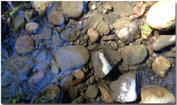
Cobble
2. Kawana Terrace Road
Directly from Taylor Mountain flows Kawana Springs Creek, which runs down to Colgan Avenue, where it becomes the waterway we know as Colgan Creek. Our first stop is on Kawana Springs Creek, just off Kawana Terrace Road, near the entrance to Taylor Mountain Park. Here, the stream has rock cobble, washed down from Taylor Mountain. A healthy trout stream would have such clean cobble, and the spaces between the rocks are necessary to aquatic insects and to salmonid eggs. When sediment fills such spaces, neither fish nor cold-water insects can use the cobble.

Buckeye
Kawana Terrace has healthy riparian vegetation, including a magnificent buckeye, newly planted valley oaks and an Oregon ash. The native arroyo willow growing in the channel can block stream flow with its multiple trunks. Single-trunked willows would work willows would be preferable. Non-natives here include Himalayan blackberry, a tasty but invasive legacy of Luther Burbank. This shrub can out-compete natives and impair stream health.

Valley Oak
Between here and our next stop, the stream along Kawana Terrace Road has fairly decent habitat conditions; good city planning calls for setbacks here, on the north bank, which prevented development from getting too close to creek habitat. There is plenty of room to plant more native trees on the north bank, where more shade and habitat would improve the reach.
3. Petaluma Hill Road

Just north of where Petaluma Hill Road meets Kawana Springs Road, Kawana Springs Creek flows through a cement channel below Petaluma Hill Road. The undercrossing is a classic box culvert which can block fish passage, particularly juvenile fish. Long stretches of flat concrete with water sheeting across it are difficult for a fish to negotiate. This lack of “connectivity” in a stream habitat reach has a detrimental effect on a fish population’s ability to move up and down the channel freely to seek food or shelter.
We also see a large storm drain entering the box culvert from the north. This drain can introduce pollutants into the creek if upstream residents are not careful with what enters their storm drain intakes. Here the native live oaks provide shade, but more tree canopy would benefit the creek, here and also downstream.
Parts of this reach are being restored, yet more native trees are needed. Their shade would not only lower ambient air and water temperatures, but also reduce the channel-clogging vegetation that thrives in sunlight. The stream bed does have some good cobble, but this reach of stream channel is especially vulnerable to becoming filled with fine sediment.
Better erosion control upstream would help protect the cobble from filling in and discourage growth of arroyo willow in the channel, which can impair flood flows.
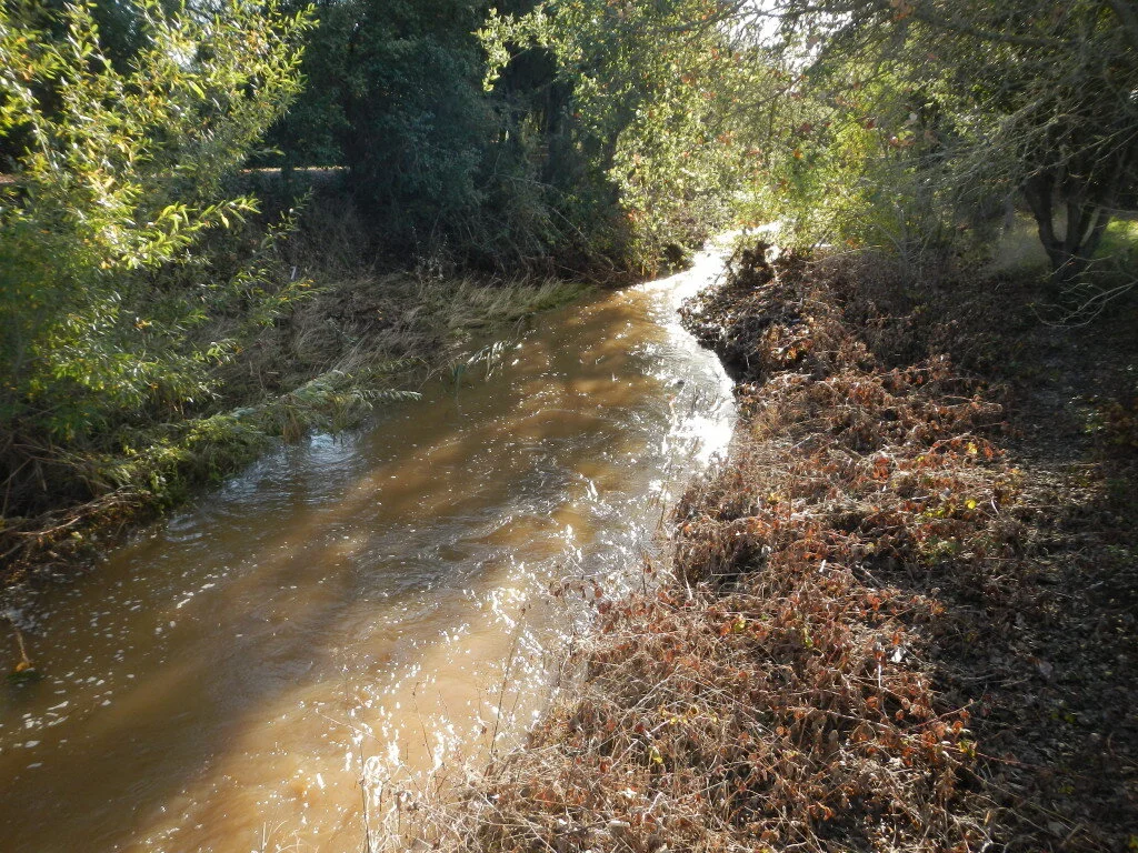
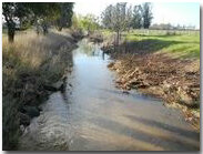
4. Kawana Springs Creek
Kawana Springs Creek continues along a natural channel below Petaluma Hill Road, including a stretch by Colgan Creek Park. Here, where the stream bed flattens out, we can see where a great deal of sediment has been deposited.

This creek stretch behind Costco (also pictured above) needs shade from more native trees.
Native trees here include live oak, valley oak, black walnut, Oregon ash, red willow and arroyo willow. The creek stretch by the Costco loading dock is identified as a “native oak regeneration” area. But few oaks are regenerating here, and many more trees—perhaps a mixture of other native species—are needed to shade and cool air and water temperatures.
Behind the nearby Costco store, an underground concrete channel crosses the parking lot and brings Colgan Creek to merge with Kawana Springs Creek at Colgan Avenue.
5. Colgan Avenue Box Culvert

Colgan Creek, emerging on Colgan Avenue
The Colgan Avenue box culvert is important to look at, because it discharges both creek water and storm drain runoff. Another creek might carry fresh rainwater from wooded hillsides and marshes, but Colgan Creek conveys mostly urban runoff.
Some of that runoff originates at the storm drains of the Sonoma County Fairgrounds, where concentrations of animal waste have been a source of pollution in the past. This area of Santa Rosa also has a large number of abandoned, underground fuel storage tanks that can leak and cause pollution if not properly managed.

When it emerges from the box culvert, Colgan Creek travels via channels and culverts, flowing under Santa Rosa Avenue and Highway 101. On the bottom of the concrete channel (seen at right) willows and reeds grow in the sediments deposits, and will likely be removed because they can block high stream flows during a winter rain storm.
An underground fuel tank at the southwest corner of Colgan and Santa Rosa avenues was the site of a groundwater cleanup project, now completed. When Colgan Creek crosses under Corby Avenue, it finally reaches a natural channel, and from there flows freely to our next water quality test site at Hearn Avenue.
6. Hearn Avenue

Just upstream of Hearn Avenue is our next testing site. A Sonoma County Water Agency service road runs along this reach, and the Smart Train tracks parallel the waterway upstream of Hearn Avenue where a new railroad bridge crosses Colgan Creek. (The old bridge often got clogged with debris in heavy rains, which backed up floodwaters to Corby Avenue and caused flooding of homes built too close to the creek.)
Here in the creek we see an excess of channel-blocking reeds, which thrive in lots of sun. A canopy of diverse native trees here would discourage growth of invasive plants and benefit this reach in many ways.
Downstream from Hearn Avenue is a storm drain depositing runoff from parking lots, supply yards, auto sales yards and other businesses. Pollution from these areas will enter Colgan Creek, unless safe storm water practices are used.
7. Victoria Drive
The Victoria Drive water testing site contains a concrete channel that brings to mind a cinematic image of the Los Angeles River, as it appeared in the 1954 sci-fi thriller: “Them!”
Sheet flow of water across concrete channel bottoms can be impossible for steelhead or salmon to negotiate without periodic resting places. These concrete aprons are part of a legacy of “flood channel” engineering solutions dating back half a century. Current science calls for riparian setbacks to keep concrete a healthy distance from the waterway, a wider channel that curves, and a natural stream bottom.

The concrete in the Victoria Drive channel prevents tree growth and shade, so too much sunlight is hitting the water, encouraging reed growth that can block water flow. More trees and shade will discourage unwanted plants and contribute to a healthier creek ecosystem. The planned restoration project will restore the creek from here to Bellevue Avenue.
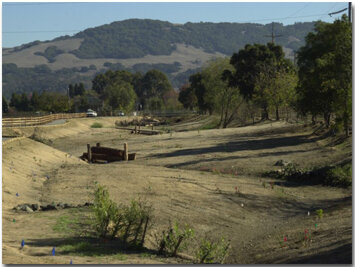
8. Dutton Meadow
Colgan Creek flows under a bridge at Dutton Meadow, near Bellevue Avenue in a natural stream bed, which presents no barrier to fish passage. At this site, restoration work is transforming this section of “flood control channel” into a healthy riparian ecosystem. Among the many benefits of the improved site will be the opportunity for student riparian biology studies, done on site.
View downstream from Dutton Meadow
Downstream the channel has been widened and curved, with natural stream features added to create pools for fish habitat, and riffles with clean gravels to support healthy aquatic insect populations—a key food source for cold water fish.
View upstream towards Dutton Meadow after stream widening and re-contouring
Large-growing tree species will be planted here to create cooling shade and to discourage the growth of invasives. Native specimens have been planted in this reach, including both red and yellow willows, and some of the native sedges used in Pomo basket making. The high school at this site is named for Pomo basket artist and teacher, Elsie Allen.
Comparing the water quality here with the downstream end of the restoration reach will provide an indication, in the coming years, of how effective the restoration has been. Native trees along this reach include black walnut and live oak. There are also non-native cork oaks, of which wine corks are made.
9. Bellevue Avenue

Sprigged willows at the Bellevue Avenue site
The Bellevue Avenue site is the downstream end of the phase 1 restoration reach. In early November of 2014, after completion of the restoration work, native willows were seen sprouting in the waterway which was still dry during record drought—benefiting from the high water table here.